The Tigris Tunnel: The Lost Source of the Great River in the Eastern Taurus Mountains
The Tigris Tunnel (Dicle Tüneli, German: Tigristunnel) is a natural and archaeological monument in the province of Diyarbakır in southeastern Turkey, in the Eastern Taurus Mountains. Here, in a narrow gorge, one of the sources of the Tigris River cuts through a limestone massif via a long underground passage, forming a rare natural phenomenon—a karst tunnel through which a real mountain river flows. But the Tigris Tunnel is famous not only for its geological features: its walls preserve Assyrian cuneiform inscriptions and reliefs from the 9th century BCE, left by Kings Tiglat-Pileser I and Salmanasar III, who personally visited this site, considering the source of the Tigris to be the edge of the known world. This is one of the most distant and inaccessible testimonies to Assyrian civilization, a unique “signature of the great kings” at the threshold of Mesopotamia.
History and Origin
The Tigris—along with the Euphrates—is one of the two great rivers between which the Sumerian and Akkadian civilizations arose. For the ancient Mesopotamians, the source of the Tigris was a site of mythological significance: it was considered the boundary of the inhabited world, the gateway to the mountains, and simultaneously a symbol of fertility. The Assyrian kings, who founded the first world empire, repeatedly launched military campaigns northward into the mountains of Nairi and Urartu, reaching these places.
The first of the rulers to leave an inscription here was Tiglath-Pileser I (reigned c. 1114–1076 BCE). He personally reached the “source of the Tigris” three times and ordered a commemorative cuneiform inscription and a relief depicting himself to be carved into the rock near the tunnel. About two centuries later, in the 9th century BCE, Salmanasar III (859–824 BCE)—one of Assyria’s most warlike kings—also came here. He also carved several reliefs into the rocks and described his journey in detail in the so-called “Black Obelisks” and chronicles found at Kalhu (modern-day Nimrud). These texts mention the “mouth of the river” and the rituals the king performed at the tunnel itself, offering sacrifices to the gods Ashur and Adad.
In antiquity, the tunnel and the sources of the Tigris were forgotten by Europeans, and in the Middle Ages, they remained known only to the local population—the Kurds and Armenians, who used the surrounding caves as shelters. These sites were rediscovered by science in the 1860s by the English travelers Henry Layard and Horace Rassam, who were searching for Assyrian antiquities in Kurdistan. German expeditions conducted detailed surveys in 1899 and 1937. Today, the site is located in the mountains between the districts of Lice and Hazro, at an altitude of about 1,450 meters, and is still considered one of Turkey’s least-visited historical monuments.
Architecture and What to See
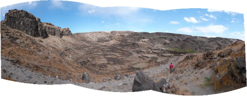
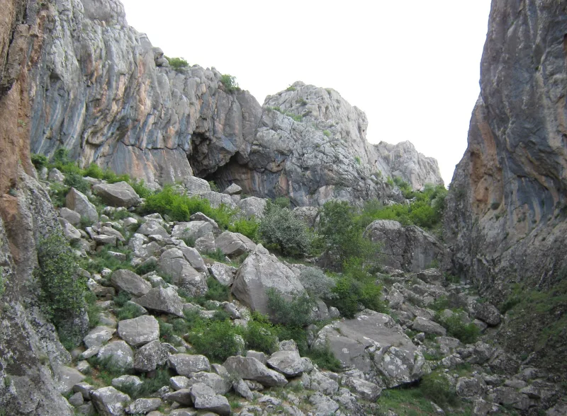
The Tigris Tunnel is a place where nature’s and humanity’s architecture converge. The underground passage itself is a creation of karst processes: over millions of years, water dissolved the limestone until it carved out a channel about a kilometer long, through which one of the Tigris’s headwaters now flows.
The natural tunnel and its exit
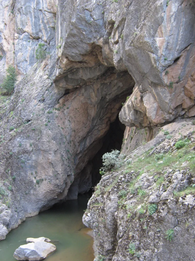
The main highlight of the route is the river’s exit from the tunnel. Here, the water bursts out of a dark arch framed by light-gray limestone and rushes down a pebble-strewn bed into the green valley. The height of the arch at the entrance reaches 8–10 meters, and the width—up to 15 meters. You can only enter the tunnel in the summer, when the water level is at its lowest, and only for a short distance: beyond that, equipment and an experienced guide are required.
Assyrian reliefs and inscriptions
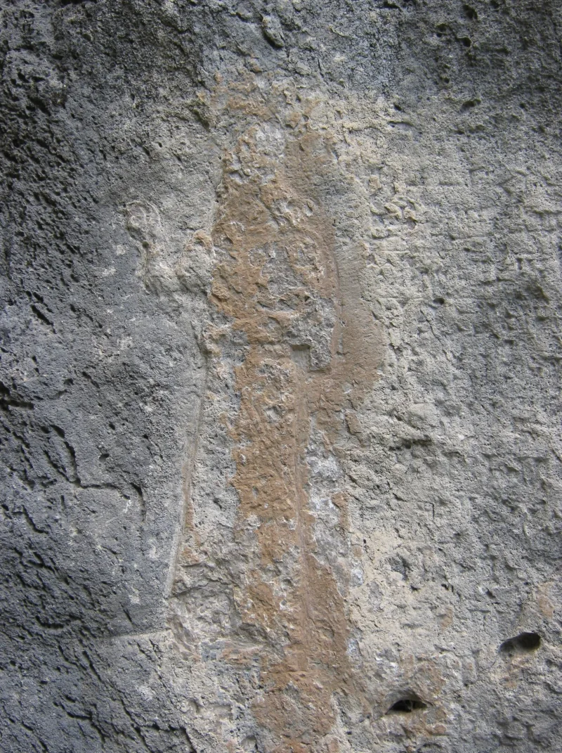
The main historical treasure consists of two reliefs on the rocks at the tunnel entrance and in a small cave above it. The first depicts a king facing right with his hand raised—a characteristic iconography of Assyrian monarchs in a pose of worshiping the gods. Above the figure and next to it is a cuneiform text in which the king refers to himself as “king of the universe, king of the four corners of the world.” This relief is attributed to Tiglath-Pileser I. The second relief, of a later style and in better condition, is attributed to Salmanasar III. Both reliefs have suffered significant weathering, yet the silhouettes and part of the inscription are still legible. Inside the cave above the tunnel is a third inscription, completing the complex.
Surrounding Landscape
The valley into which the Tigris flows is a narrow canyon with steep slopes covered in oak and juniper. Towering above it are the spurs of the Eastern Taurus—a mountain range that remains one of the most pristine in Turkey. From the highest points of the trail, a panorama opens up of several parallel ridges and plateaus, along which trade and military routes from Assyria to Urartu once passed in ancient times. Other ancient sites can be found nearby: the remains of fortresses and rock-cut tombs, presumably dating to the Early Iron Age.
Connection to other Assyrian monuments
The Tigris Tunnel is part of a group of high-altitude Assyrian monuments, along with the reliefs at Egil (ancient Tushpan, on the shore of the reservoir) and Birklen. All of them arose as a result of the Assyrian kings’ campaigns to the north and form a unique “memorial route” along which the empire’s rulers recorded their territorial claims.
Interesting Facts and Legends
- In one of his inscriptions, Tiglath-Pileser I boastfully claims that he was “the first of kings to reach the source of the Tigris,” whereas in reality, rulers from earlier eras had visited this place before him—though this is not confirmed in writing.
- In local Kurdish tradition, the tunnel is considered a “gateway to the underworld”; in the past, offerings were left here for the river spirits, asking for a good harvest and abundant rains.
- On the relief of Salmanasar III, traces of depictions of the gods Ashur and Adad—deities responsible for war and thunderstorms—are visible next to the figure of the king. This is an extremely rare instance where Assyrian iconography has survived in the open air so far from the center of the empire.
- One of the two main streams forming the Tigris flows from this source (Birkleyn); the second comes from the northwest, and they merge downstream of Lijje.
- A detailed description of the Assyrian ceremonies at the tunnel is contained in the so-called “Inscription of the Bronze Gates of Balawat”—relief panels found at Nimrud and now housed in the British Museum.
- Due to its inaccessibility, the site was unguarded for a long time: in the 20th century, part of the inscriptions was lost as a result of blasting during the construction of a local road.
- Today, the Tiger Tunnel is included on the UNESCO World Heritage Tentative List under the general title “The Sources of the Tigris—Birken/Birklenin Reliefs.”
How to get there
The Tigris Tunnel is located in the mountains between the districts of Lice and Hazro in Diyarbakır Province, 90 km northeast of the city of Diyarbakır. The nearest airport is Diyarbakır (DIY), with regular flights from Istanbul and Ankara. There is a paved highway from Diyarbakır to Lice; in Lice itself, it is advisable to hire a local driver with a jeep or 4×4—the last 10–15 km of the road are unpaved, especially after rain. The hike from the nearest village takes about an hour along a trail by the stream. Hiking alone is not recommended: the trail is poorly marked, and without a local guide, it’s easy to miss the landmarks. It’s best to plan your visit as a day trip from Diyarbakır, leaving early in the morning to return before dark.
Tips for travelers
The best time to visit is late June through September, when water levels allow you to get close to the tunnel itself and examine the rock formations. In spring, the road is often washed out, and in winter, there is snow high in the mountains. Bring sturdy hiking boots, a flashlight (it’s dark inside the tunnel even during the day), a supply of water, and a light jacket—it’s cool near the water even in the summer heat. Water-resistant gear (rubber boots or trekking sandals) will make it much easier to reach the inscriptions. Please treat the site with respect: the Assyrian reliefs are fragile; touching them, let alone making rubbings, is strictly prohibited. Do not leave trash behind or start fires in the valley. Before your trip, check with the Diyarbakır tourist office regarding the current situation: the region has historically been an area of instability, and permission from the gendarmerie is sometimes required. Combine your visit with a tour of the ancient city of Diyarbakır (a UNESCO site), its basalt walls, the On Gözlü Bridge, and the Hevsel Gardens. The Tigris Tunnel is a destination for travelers who value authenticity over comfort: here, history speaks without artifice, in the rush of the river and the rustling of the wind through the weathered rocks.